Lower Fox Land Conservation Plan
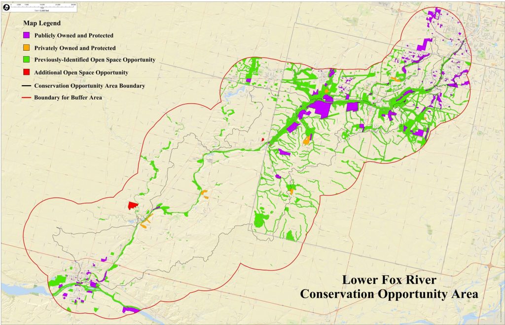
The voluntary Lower Fox River Land Conservation Planning Project began to develop a recognized plan to guide local preservation entities and individuals in land preservation efforts along the Lower Fox River, its tributaries, and the Lower Fox River Conservation Opportunity Area. The Kendall and LaSalle County portions of the Lower Fox River watershed have been identified as having important conservation value by the Illinois Department of Natural Resources.
The Plan:
The plan:
- Is strictly voluntary.
- Was developed by a diverse group of local stakeholders in Kendall and LaSalle Counties, including private landowners, local municipalities, counties, agencies, and other groups facilitated by The Conservation Foundation.
- Determined priorities regarding natural resource protection.
- May raise the likelihood of obtaining funding for projects by complying with the local and state plans.
- This planning phase of this strictly voluntary project was led by the stakeholders with support from The Conservation Foundation, who served as a facilitator.
The overall goal of the project was to develop a recognized plan for local entities and individuals to use in land preservation efforts in the Lower Fox River basin for the protection of water quality, natural resources, and open space. Specific goals and objectives are:
- Develop a prioritized list of potential parcels to be preserved in the Lower Fox River Conservation Opportunity Area
- Develop a list of potential preservation entities and funding sources
- Create tools for use in future planning and protection efforts: develop a GIS map of parcels and a stakeholders’ interactive website to update progress
- Obtain endorsement of the plan from local private and public entities
- Encourage a stronger understanding of the protection of natural resources
The final product of this planning process was a prioritized map of parcels that would benefit from voluntary preservation measures. The map serves as a coordinated guide to landowners, municipalities, and conservation organizations to supplement their existing plans. By acting in accordance with this guide, voluntary preservation projects could receive priority status for grant funding.
View the brochure for the project.
Learn more about how you can help preserve and protect the Fox River in your community.
For more information and to pursue your land preservation options, please contact our Vice President for Land & Watershed Programs, Dan Lobbes, via email or call 630-428-4500, Ext. 201.


